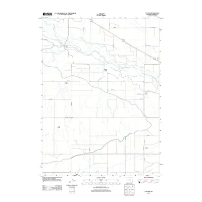
2012 Map of Cottier
USGS Topo · Published 2012About this map
The N Platte River meanders through this portion of Goshen County, defining a landscape shaped by water and high plains topography. The small settlement of Cottier sits at a rural crossroads in the southeast, while Heldt is situated further west along the southern border. The terrain is notably dissected by several intermittent drainages, including Sand Draw, Hefflen Draw, Angel Draw, and Grant Draw, which all feed toward the river valley. To the southwest, the distinctive Three Buttes rise above the surrounding flats, serving as a prominent natural landmark for the region.
Find a feature on this map
39 named features on this map. Tap any name to fly to it.
Don’t see what you’re looking for? This feature index may not catch every label — zoom into the map to look around manually.
Map Details
Editions of this 2012 Cottier Map
This is the sole edition of this map. No revisions or reprints were ever made.
Other maps of this area

1896 · Patrick
USGS Topo · 1:125,000

1899 · Goshen Hole
USGS Topo · 1:125,000

1954 · Torrington
USGS Topo · 1:250,000

1954 · Cheyenne
USGS Topo · 1:250,000

1958 · Cheyenne
USGS Topo · 1:250,000

1958 · Torrington
USGS Topo · 1:250,000

1960 · Habig Spring
USGS Topo · 1:24,000

1960 · Huntley
USGS Topo · 1:24,000

1960 · Veteran
USGS Topo · 1:24,000
1960 · Barnes
USGS Topo · 1:24,000