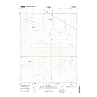
2015 Map of Cottier
USGS Topo · Published 2015About this map
The North Platte River winds through this section of Goshen County, creating a fertile valley flanked by distinct geographical landmarks. To the west of the river, London Flats and Sand Draw define the lower-lying terrain, while the southern reaches of the map are punctuated by the prominent elevation of Three Buttes. These landforms, alongside several seasonal drainage features like Angel Draw and Hefflen Draw, dictate the placement of local infrastructure and historic settlements.
Find a feature on this map
38 named features on this map. Tap any name to fly to it.
Don’t see what you’re looking for? This feature index may not catch every label — zoom into the map to look around manually.
Map Details
Editions of this 2015 Cottier Map
This is the sole edition of this map. No revisions or reprints were ever made.
Other maps of this area

1896 · Patrick
USGS Topo · 1:125,000

1899 · Goshen Hole
USGS Topo · 1:125,000

1954 · Torrington
USGS Topo · 1:250,000

1954 · Cheyenne
USGS Topo · 1:250,000

1958 · Cheyenne
USGS Topo · 1:250,000

1958 · Torrington
USGS Topo · 1:250,000

1960 · Habig Spring
USGS Topo · 1:24,000

1960 · Huntley
USGS Topo · 1:24,000

1960 · Veteran
USGS Topo · 1:24,000
1960 · Barnes
USGS Topo · 1:24,000