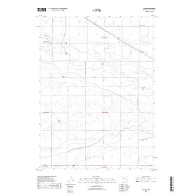
2017 Map of Cottier
USGS Topo · Published 2017About this map
The North Platte River defines the northern reaches of this Goshen County landscape, winding through a region marked by extensive irrigation infrastructure and named agricultural settlements. Local identity is anchored by small communities such as Cottier, London Flats, and Heldt, while the industrial history of the valley is highlighted by the presence of Sugar Factory Rd. The terrain south of the river valley is characterized by a series of distinct drainage patterns including Sand Draw, Hefflen Draw, and Angel Draw, which cut through the high plains toward the river. To the west, the topographic prominence of Three Buttes stands out against the surrounding flats, providing a significant landmark for the area's rural road network. Water management is central to the area's layout, evidenced by Canal Rd and Power Plant Rd serving the river corridor, alongside smaller water bodies like Housen Lake.
Find a feature on this map
48 named features on this map. Tap any name to fly to it.
Don’t see what you’re looking for? This feature index may not catch every label — zoom into the map to look around manually.
Map Details
Editions of this 2017 Cottier Map
This is the sole edition of this map. No revisions or reprints were ever made.
Other maps of this area

1896 · Patrick
USGS Topo · 1:125,000

1899 · Goshen Hole
USGS Topo · 1:125,000

1954 · Torrington
USGS Topo · 1:250,000

1954 · Cheyenne
USGS Topo · 1:250,000

1958 · Cheyenne
USGS Topo · 1:250,000

1958 · Torrington
USGS Topo · 1:250,000

1960 · Habig Spring
USGS Topo · 1:24,000

1960 · Huntley
USGS Topo · 1:24,000

1960 · Veteran
USGS Topo · 1:24,000
1960 · Barnes
USGS Topo · 1:24,000