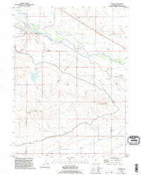
1990 Map of Cottier
USGS Topo · Published 1995About this map
The Emigrant Trail cuts a diagonal path across this landscape, tracing the historic movement of pioneers through the North Platte valley. This 1990 revision illustrates the enduring presence of the North Platte River and its accompanying irrigation infrastructure, including the Fort Laramie Canal and Torrington Ditch, which supported local ranching and agriculture. The map identifies key historical markers such as the Rock Ranch (Historical) and a dedicated Historical Monument near the riverbanks. Small rail-side or crossroads settlements like Cottier and Heldt appear alongside natural landmarks such as Three Buttes and the open expanse of London Flats. The intricate network of draws, including Sand Draw and Hefflen Draw, highlights the drainage patterns of the high plains terrain.
Find a feature on this map
20 named features on this map. Tap any name to fly to it.
Don’t see what you’re looking for? This feature index may not catch every label — zoom into the map to look around manually.
Map Details
Editions of this 1990 Cottier Map
This is the sole edition of this map. No revisions or reprints were ever made.
Other maps of this area

1896 · Patrick
USGS Topo · 1:125,000

1899 · Goshen Hole
USGS Topo · 1:125,000

1954 · Torrington
USGS Topo · 1:250,000

1954 · Cheyenne
USGS Topo · 1:250,000

1958 · Cheyenne
USGS Topo · 1:250,000

1958 · Torrington
USGS Topo · 1:250,000

1960 · Habig Spring
USGS Topo · 1:24,000

1960 · Huntley
USGS Topo · 1:24,000

1960 · Veteran
USGS Topo · 1:24,000
1960 · Barnes
USGS Topo · 1:24,000