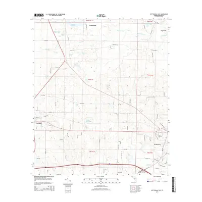
2015 Map of Cottondale East
USGS Topo · Published 2015About this map
The Chipola River corridor north of Marianna anchors this 2015 survey of Jackson County, Florida. The landscape is defined by its hydrology, featuring a dense concentration of named ponds and springs such as Webbville Spring, Tanner Springs, and Open Pond. Historically significant water-management sites and milling locations are prevalent throughout the terrain, including Waddells Mill and the expansive Williams Mill Pond. The mapping also highlights vital crossings and infrastructure that have shaped local transport for generations, notably the Bellamy Bridge and Christoff Ferry Ln near the eastern border. To the west, the community of Cottondale marks a transition from the riverine lowlands toward more established residential and commercial patterns, while features like Caraway Mill Pond in the southeast reflect the area's continued connection to its rural and agricultural heritage.
Find a feature on this map
110 named features on this map. Tap any name to fly to it.
Don’t see what you’re looking for? This feature index may not catch every label — zoom into the map to look around manually.
Map Details
Editions of this 2015 Cottondale East Map
This is the sole edition of this map. No revisions or reprints were ever made.
Other maps of this area

1952 · Oakdale
USGS Topo · 1:24,000

1952 · Kynesville
USGS Topo · 1:24,000

1952 · Cottondale East
USGS Topo · 1:24,000

1952 · Malone
USGS Topo · 1:24,000

1952 · Campbellton
USGS Topo · 1:24,000

1952 · Cottondale West
USGS Topo · 1:24,000

1952 · Sills
USGS Topo · 1:24,000
1952 · Alford
USGS Topo · 1:24,000

1952 · Marianna
USGS Topo · 1:24,000

1954 · Tallahassee
USGS Topo · 1:250,000