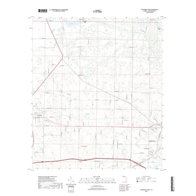
2018 Map of Cottondale East
USGS Topo · Published 2018About this map
The agrarian landscape of western Jackson County is defined by a dense network of water features and historic mills. The intersection of local industry and natural hydrology is prominent at Waddells Mill and its associated Waddells Mill Pond, alongside other industrial water sites like Williams Mill Pond and Caraway Mill Pond. These locations hint at the community's historical reliance on milling and the Chipola River drainage system.
Find a feature on this map
110 named features on this map. Tap any name to fly to it.
Don’t see what you’re looking for? This feature index may not catch every label — zoom into the map to look around manually.
Map Details
Editions of this 2018 Cottondale East Map
This is the sole edition of this map. No revisions or reprints were ever made.
Other maps of this area

1952 · Oakdale
USGS Topo · 1:24,000

1952 · Kynesville
USGS Topo · 1:24,000

1952 · Cottondale East
USGS Topo · 1:24,000

1952 · Malone
USGS Topo · 1:24,000

1952 · Campbellton
USGS Topo · 1:24,000

1952 · Cottondale West
USGS Topo · 1:24,000

1952 · Sills
USGS Topo · 1:24,000
1952 · Alford
USGS Topo · 1:24,000

1952 · Marianna
USGS Topo · 1:24,000

1954 · Tallahassee
USGS Topo · 1:250,000