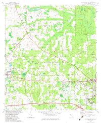
1982 Map of Cottondale East
USGS Topo · Published 1982About this map
Marianna and Cottondale anchor this Jackson County landscape in the early 1980s, a region defined by an extensive network of spring-fed ponds and the winding Chipola River. The area north of Marianna is notably dense with small water bodies such as Snelling Pond and Roulhac Pond, which feed into Russ Mill Creek and Waddells Mill Creek. Historically significant sites like Waddells Mill and the nearby Waddells Millpond illustrate the water-driven industry of earlier eras, while Webbville Spring and Tanner Springs point to the subterranean hydrology of the Florida panhandle. The Louisville and Nashville rail line cuts across the terrain, connecting these agrarian hubs. Along the river, the Bellamy Bridge and Christoff Ferry Landing represent critical historical crossing points, while various churches like Springfield Ch and New Hope Ch serve as local landmarks for family researchers.
Find a feature on this map
65 named features on this map. Tap any name to fly to it.
Don’t see what you’re looking for? This feature index may not catch every label — zoom into the map to look around manually.
Map Details
Editions of this 1982 Cottondale East Map
This is the sole edition of this map. No revisions or reprints were ever made.
Other maps of this area

1952 · Oakdale
USGS Topo · 1:24,000

1952 · Kynesville
USGS Topo · 1:24,000

1952 · Cottondale East
USGS Topo · 1:24,000

1952 · Malone
USGS Topo · 1:24,000

1952 · Campbellton
USGS Topo · 1:24,000

1952 · Cottondale West
USGS Topo · 1:24,000

1952 · Sills
USGS Topo · 1:24,000
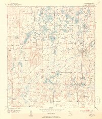
1952 · Alford
USGS Topo · 1:24,000

1952 · Marianna
USGS Topo · 1:24,000

1954 · Tallahassee
USGS Topo · 1:250,000