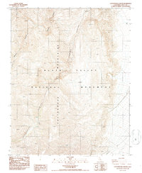
1987 Map of Cottonwood Canyon
USGS Topo · Published 1987About this map
Death Valley National Monument defines this landscape of high desert drainage and dramatic elevation changes in the late twentieth century. Centered on the rugged topography of Cottonwood Canyon, the map captures a network of deep-cut washes and canyon systems, including Marble Canyon in the north and Lemoigne Canyon to the south. This 1987 provisional edition highlights the stark geological features of the Cottonwood Mountains, where a solitary Spring provides a rare water source in the arid environment. The map's contour lines and spot elevations reveal the complex drainage patterns that funnel through these canyons toward the valley floor, documenting the wilderness character of Inyo County before the monument was redesigned as a national park.
Find a feature on this map
6 named features on this map. Tap any name to fly to it.
Don’t see what you’re looking for? This feature index may not catch every label — zoom into the map to look around manually.
Map Details
Editions of this 1987 Cottonwood Canyon Map
2 editions found
Other maps of this area

1908 · Ballarat
USGS Topo · 1:250,000

1913 · Ballarat
USGS Topo · 1:250,000

1948 · Death Valley
USGS Topo · 1:250,000

1951 · Panamint Butte
USGS Topo · 1:62,500

1951 · Marble Canyon
USGS Topo · 1:62,500

1952 · Stovepipe Wells
USGS Topo · 1:62,500

1952 · Emigrant Canyon
USGS Topo · 1:62,500

1954 · Death Valley
USGS Topo · 1:250,000

1956 · Death Valley
USGS Topo · 1:250,000

1957 · Death Valley
USGS Topo · 1:250,000