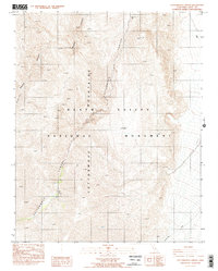
1987 Map of Cottonwood Canyon
USGS Topo · Published 1987About this map
Panamint Mountains dominate this high-elevation terrain within Death Valley National Monument, where dramatic geological formations define the landscape of the late 1980s. The map illustrates a network of deep drainages, including the prominent Cottonwood Canyon and the winding Marble Canyon. These corridors have long served as vital routes through the arid environment, supported by a critical Spring located near the canyon floor. The presence of Dead Horse Canyon and Lemoigne Canyon further showcases the complex desert topography. A single 4wd track provides the only vehicular access through this section of the monument, emphasizing the isolation and technical nature of travel in the western Mojave before more modern park infrastructure was developed.
Find a feature on this map
8 named features on this map. Tap any name to fly to it.
Don’t see what you’re looking for? This feature index may not catch every label — zoom into the map to look around manually.
Map Details
Editions of this 1987 Cottonwood Canyon Map
2 editions found
Other maps of this area

1908 · Ballarat
USGS Topo · 1:250,000

1913 · Ballarat
USGS Topo · 1:250,000

1948 · Death Valley
USGS Topo · 1:250,000

1951 · Panamint Butte
USGS Topo · 1:62,500

1951 · Marble Canyon
USGS Topo · 1:62,500

1952 · Stovepipe Wells
USGS Topo · 1:62,500

1952 · Emigrant Canyon
USGS Topo · 1:62,500

1954 · Death Valley
USGS Topo · 1:250,000

1956 · Death Valley
USGS Topo · 1:250,000

1957 · Death Valley
USGS Topo · 1:250,000