
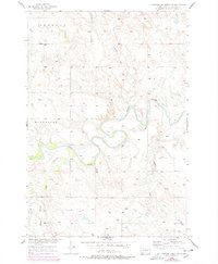
1956 Map of Cottonwood Creek NW
USGS Topo · Published 1957About this map
The Grand River carves a dramatic, winding path across this portion of Corson County, shaping the surrounding plains of Sherman and Riverside. In the mid-1950s, this landscape was defined by its water systems, including the southern convergence of Horse Black Butte Creek and the eastern flow of Meadow Creek. The intricate contour lines reveal the complex breaks and draws typical of the Missouri River Basin development area, showing how the terrain descends toward the river valley. While large settlements are absent, the map documents the essential drainage network of Cedar Creek and the established township boundaries that organized this rural ranching country during the post-war era.
Find a feature on this map
8 named features on this map. Tap any name to fly to it.
Don’t see what you’re looking for? This feature index may not catch every label — zoom into the map to look around manually.
Map Details
Editions of this 1956 Cottonwood Creek NW Map
2 editions found
Other maps of this area

1953 · McIntosh
USGS Topo · 1:250,000

1956 · Cottonwood Creek NE
USGS Topo · 1:24,000

1956 · Cottonwood Creek SE
USGS Topo · 1:24,000

1956 · Cottonwood Creek SW
USGS Topo · 1:24,000

1958 · McIntosh
USGS Topo · 1:250,000

1972 · Morristown SE
USGS Topo · 1:24,000

1972 · Skull Butte
USGS Topo · 1:24,000

1972 · Thunder Hawk SE
USGS Topo · 1:24,000

1972 · Twin Butte
USGS Topo · 1:24,000

1972 · Black Horse Butte NE
USGS Topo · 1:24,000