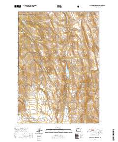
2020 Map of Cottonwood Reservoir
USGS Topo · Published 2020About this map
Malheur National Forest occupies the northern reaches of this high-desert landscape in Harney County, where the terrain transitions from timbered slopes to the arid basin of the Otis Valley. Central to this 2020 survey is the Se-ng-abi Huudi Reservoir, a vital water source fed by the namesake Se-ng-abi Huudi Cr. The map reveals a complex system of water management and livestock support, evidenced by features like the Altnow Ditch and several named water sources such as Dipping Vat Spring, Jackson Spring, and Antelope Spring. This network of springs and man-made impoundments underscores the essential infrastructure required for ranching in this dry region. To the east, the Beede Desert and Rocky Basin highlight the more desolate stretches of the territory, while the Crane-Prairie-Drewsey Rd provides the primary transit link through this expansive high-elevation environment.
Find a feature on this map
24 named features on this map. Tap any name to fly to it.
Don’t see what you’re looking for? This feature index may not catch every label — zoom into the map to look around manually.
Map Details
Editions of this 2020 Cottonwood Reservoir Map
This is the sole edition of this map. No revisions or reprints were ever made.
Other maps of this area

1908 · Ironside Mountain
USGS Topo · 1:125,000

1955 · Burns
USGS Topo · 1:250,000

1955 · Canyon City
USGS Topo · 1:250,000

1958 · Burns
USGS Topo · 1:250,000

1959 · Burns
USGS Topo · 1:250,000

1959 · Canyon City
USGS Topo · 1:250,000

1966 · Beulah
USGS Topo · 1:62,500

1968 · Drewsey
USGS Topo · 1:62,500

1970 · Flag Prairie
USGS Topo · 1:62,500

1970 · Castle Rock
USGS Topo · 1:62,500