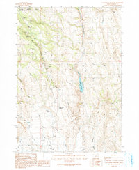
1990 Map of Cottonwood Reservoir
USGS Topo · Published 1991About this map
Cottonwood Reservoir and the headwaters of Cottonwood Creek anchor this high-desert landscape on the southern edge of the Malheur National Forest. This 1990 provisional map documents a region defined by water management and resource extraction, where the Otis Valley and Beede Desert meet. Evidence of range life and industry is scattered throughout the terrain, from a Landing Strip and Corral to various prospects, a Gravel Pit, and several Borrow Pits. The map reveals a reliance on natural and engineered water sources, including Antelope Spring, Dipping Vat Spring, and the Squaw Creek Reservoir, which is supported by a series of Check Dams. This survey preserves the exact placement of these vital desert landmarks as they appeared in the late twentieth century.
Find a feature on this map
24 named features on this map. Tap any name to fly to it.
Don’t see what you’re looking for? This feature index may not catch every label — zoom into the map to look around manually.
Map Details
Editions of this 1990 Cottonwood Reservoir Map
This is the sole edition of this map. No revisions or reprints were ever made.
Other maps of this area

1908 · Ironside Mountain
USGS Topo · 1:125,000

1955 · Burns
USGS Topo · 1:250,000

1955 · Canyon City
USGS Topo · 1:250,000

1958 · Burns
USGS Topo · 1:250,000

1959 · Burns
USGS Topo · 1:250,000

1959 · Canyon City
USGS Topo · 1:250,000

1966 · Beulah
USGS Topo · 1:62,500

1968 · Drewsey
USGS Topo · 1:62,500

1970 · Flag Prairie
USGS Topo · 1:62,500

1970 · Castle Rock
USGS Topo · 1:62,500