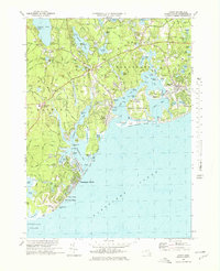
1974 Map of Cotuit
USGS Topo · Published 1978About this map
Marstons Mills and Cotuit anchor this detailed coastal survey, illustrating the complex geography of the Barnstable and Mashpee shoreline. Numerous Cranberry Bogs are scattered inland, reflecting the region's enduring agricultural identity amidst growing residential clusters like Maushop Village and Osterville. The map documents a landscape defined by intricate waterways, from the Santuit River flowing into Popponesset Bay to the protected reaches of Oyster Harbors.
Find a feature on this map
101 named features on this map. Tap any name to fly to it.
Don’t see what you’re looking for? This feature index may not catch every label — zoom into the map to look around manually.
Map Details
Editions of this 1974 Cotuit Map
4 editions found
Other maps of this area

1886 · Falmouth
USGS Topo · 1:62,500

1888 · Barnstable
USGS Topo · 1:62,500

1888 · Falmouth
USGS Topo · 1:62,500

1893 · Barnstable
USGS Topo · 1:62,500

1893 · Falmouth
USGS Topo · 1:62,500

1915 · Falmouth
USGS Topo · 1:62,500

1920 · Falmouth
USGS Topo · 1:62,500
1935 · Pocasset
USGS Topo · 1:20,000
1936 · Falmouth
USGS Topo · 1:25,000

1938 · Sandwich
USGS Topo · 1:31,680