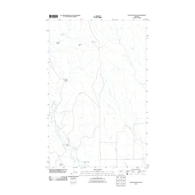
2011 Map of Coulter Coulee
USGS Topo · Published 2011About this map
Frenchman Creek winds through this northern Montana landscape, anchoring a network of drainage features and coulees that define the local topography. The area is characterized by its wide-open ranching or grazing lands, marked by features such as Big Toe Flat and a series of deep draws including School Section Coulee, Shed Coulee, and Red Mud Coulee. Water management is evident through the placement of the Morgan Reservoir and Carol Reservoir, which likely serve as vital resources in this arid environment. Transportation across this portion of Valley County is facilitated by remote routes like Frenchman Rd and Cache Creek Rd, which provide access to the various forks of Little Snake Creek and Snake Creek. The map illustrates a specialized terrain where land use is dictated by the natural flow of water and the rugged breaks of the coulees.
Find a feature on this map
14 named features on this map. Tap any name to fly to it.
Don’t see what you’re looking for? This feature index may not catch every label — zoom into the map to look around manually.
Map Details
Editions of this 2011 Coulter Coulee Map
This is the sole edition of this map. No revisions or reprints were ever made.
Other maps of this area

1954 · Glasgow
USGS Topo · 1:250,000

1957 · Glasgow
USGS Topo · 1:250,000

1958 · Glasgow
USGS Topo · 1:250,000

1984 · Thoeny Hills East
USGS Topo · 1:24,000

1984 · Snake Creek School
USGS Topo · 1:24,000

1984 · Black Calf Reservoir
USGS Topo · 1:24,000

1984 · Coulter Coulee
USGS Topo · 1:24,000

1984 · Dead Horse Coulee
USGS Topo · 1:24,000

1984 · Crow Creek Dam
USGS Topo · 1:24,000
1984 · Papoose Hills
USGS Topo · 1:24,000