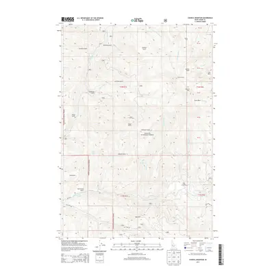
2013 Map of Council Mountain
USGS Topo · Published 2013About this map
Council Mtn dominates this high-elevation portion of the Payette National Forest, where the complex headwaters of the Weiser River system begin to take shape. The terrain is marked by significant drainages such as Warm Spring Cr and the Middle Fork Weiser River, which carve through deep gulches and basins. Evidence of forest management and early settlement is visible through landmarks like the Council Lookout and the Deseret Cabin in the north. The map also highlights the recreational utility of the land at the time, specifically the Cabin Creek Campground near the confluence of Cabin Cr and Boulder Cr. High-country features like Granite Basin and Arbuckle Basin indicate a landscape defined by glacial or erosion-formed depressions, typical of this Idaho interior range. Forest roads like Fall Creek Rd provide the primary access through these sections of the national forest.
Find a feature on this map
78 named features on this map. Tap any name to fly to it.
Don’t see what you’re looking for? This feature index may not catch every label — zoom into the map to look around manually.
Map Details
Editions of this 2013 Council Mountain Map
This is the sole edition of this map. No revisions or reprints were ever made.
Other maps of this area

1911 · Meadows
USGS Topo · 1:125,000

1954 · Council
USGS Topo · 1:62,500

1954 · New Meadows
USGS Topo · 1:62,500

1954 · Cascade
USGS Topo · 1:62,500

1955 · Baker
USGS Topo · 1:250,000

1959 · Baker
USGS Topo · 1:250,000
1973 · No Business Mtn
USGS Topo · 1:24,000

1980 · McCall
USGS Topo · 1:100,000
1985 · Cold Spring Ridge
USGS Topo · 1:24,000
1985 · Lone Tree
USGS Topo · 1:24,000