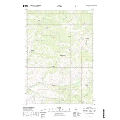
2020 Map of Council Mountain
USGS Topo · Published 2020About this map
Council Mountain dominates the landscape of this high-elevation Idaho territory within the Payette National Forest. The topography is defined by complex drainage networks and high mountain basins, including Granite Basin, Arbuckle Basin, and Bucks Basin. These alpine features feed several significant watercourses, most notably the Middle Fork Weiser River and the E Fork Weiser River.
Find a feature on this map
62 named features on this map. Tap any name to fly to it.
Don’t see what you’re looking for? This feature index may not catch every label — zoom into the map to look around manually.
Map Details
Editions of this 2020 Council Mountain Map
This is the sole edition of this map. No revisions or reprints were ever made.
Other maps of this area

1911 · Meadows
USGS Topo · 1:125,000

1954 · Council
USGS Topo · 1:62,500

1954 · New Meadows
USGS Topo · 1:62,500

1954 · Cascade
USGS Topo · 1:62,500

1955 · Baker
USGS Topo · 1:250,000

1959 · Baker
USGS Topo · 1:250,000
1973 · No Business Mtn
USGS Topo · 1:24,000

1980 · McCall
USGS Topo · 1:100,000
1985 · Cold Spring Ridge
USGS Topo · 1:24,000
1985 · Lone Tree
USGS Topo · 1:24,000