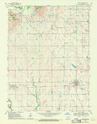
1969 Map of Courtland
USGS Topo · Published 1971About this map
The agricultural landscape of Republic and Jewell Counties is defined here by the intricate irrigation network of the Courtland Canal and Miller Canal. This 1960s-era topography reveals a transition from the upland divides near Formoso to the lower basins surrounding Courtland. Two major rail lines, the Atchison Topeka and Santa Fe and the Chicago Rock Island and Pacific, intersect this terrain, marking the corridor's historical reliance on rail for grain transport. Genealogists will find a high concentration of rural burial sites, including Laurel Hill Cem, Persinger Cem, and Mt Pleasant Cem. The presence of a Sandpit and Gravel Pit alongside watercourses like Beaver Creek and East Marsh Creek points to local extractive industries that supported the region's infrastructure during the mid-century.
Find a feature on this map
24 named features on this map. Tap any name to fly to it.
Don’t see what you’re looking for? This feature index may not catch every label — zoom into the map to look around manually.
Map Details
Editions of this 1969 Courtland Map
This is the sole edition of this map. No revisions or reprints were ever made.
Other maps of this area

1892 · Concordia
USGS Topo · 1:125,000

1894 · Mankato
USGS Topo · 1:125,000

1955 · Manhattan
USGS Topo · 1:250,000

1955 · Beloit
USGS Topo · 1:250,000

1956 · Manhattan
USGS Topo · 1:250,000

1957 · Manhattan
USGS Topo · 1:250,000

1959 · Beloit
USGS Topo · 1:250,000

1965 · Kackley
USGS Topo · 1:24,000

1966 · Scandia
USGS Topo · 1:24,000
1968 · Jamestown NW
USGS Topo · 1:24,000