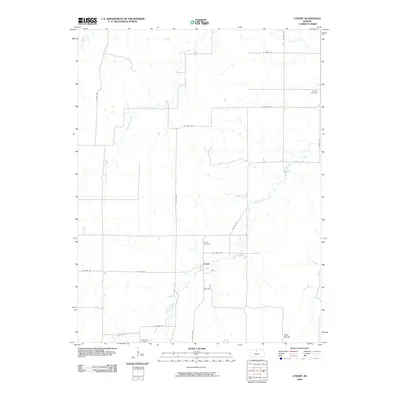
2009 Map of Covert
USGS Topo · Published 2009About this map
Covert serves as the quiet center of this agricultural landscape in Osborne County, situated along the winding path of Covert Creek. This 2009 survey reflects the enduring rural structure of North Central Kansas, where section-line roads like S 160th Ave and W 200th Dr connect a sparse network of homesteads and farms. For those tracing local history, the geography is anchored by several distinct burial sites, including Bristow Cemetery in the northeast and Cedar Bluff Cemetery in the southwest, each marking the heritage of the surrounding townships. The terrain is defined by the drainage basins of Kill Creek and East Kill Creek, leading toward the prominent elevation of Sand Mound near the southern boundary. This map captures the intersection of natural hydrology and the rectilinear grid of Kansas prairie life.
Find a feature on this map
22 named features on this map. Tap any name to fly to it.
Don’t see what you’re looking for? This feature index may not catch every label — zoom into the map to look around manually.
Map Details
Editions of this 2009 Covert Map
This is the sole edition of this map. No revisions or reprints were ever made.
Other maps of this area

1896 · Osborne
USGS Topo · 1:125,000

1953 · Bloomington
USGS Topo · 1:24,000

1953 · Osborne
USGS Topo · 1:24,000

1953 · Alton
USGS Topo · 1:24,000

1955 · Beloit
USGS Topo · 1:250,000

1959 · Beloit
USGS Topo · 1:250,000

1978 · Osborne SW
USGS Topo · 1:24,000
1978 · Paradise NW
USGS Topo · 1:24,000
1978 · Alton SW
USGS Topo · 1:24,000
1978 · Vincent
USGS Topo · 1:24,000