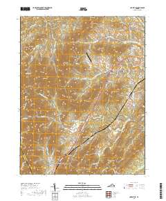
2019 Map of Covesville
USGS Topo · Published 2019About this map
Covesville and North Garden anchor this landscape in Albemarle County, where the southern reaches of the Ragged Mountains meet the fertile valleys of the Piedmont. The terrain is defined by a dense network of ridges including Chalk Mtn, Israel Mtn, and the Boaz Mountains, which dictate the winding paths of rural routes like Monacan Trail Rd and Plank Rd. The map reveals a settled rural character, with numerous family and community cemeteries such as Wild Rose Cem, Zion Cem, and Rising Sun Cem scattered across the upland hollows and valley floors. Water from the N Fork Hardware River and S Fork Hardware River drains the complex topography, supporting sites like Pagebrook Farm and the Bundoran Airport. This 2019 survey documents a region where historic road alignments and small mountain gaps continue to shape the distribution of local residences and agriculture.
Find a feature on this map
109 named features on this map. Tap any name to fly to it.
Don’t see what you’re looking for? This feature index may not catch every label — zoom into the map to look around manually.
Map Details
Editions of this 2019 Covesville Map
This is the sole edition of this map. No revisions or reprints were ever made.
Other maps of this area

1892 · Buckingham
USGS Topo · 1:125,000

1892 · Harrisonburg
USGS Topo · 1:125,000

1929 · Covesville
USGS Topo · 1:62,500

1931 · University
USGS Topo · 1:62,500

1934 · Waynesboro
USGS Topo · 1:48,000

1935 · Covesville
USGS Topo · 1:62,500

1935 · University
USGS Topo · 1:62,500

1939 · Waynesboro
USGS Topo · 1:62,500

1943 · Lovingston
USGS Topo · 1:62,500

1945 · Covesville
USGS Topo · 1:62,500