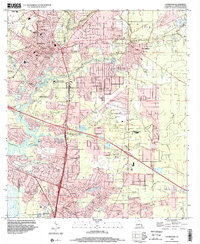
1998 Map of Covington
USGS Topo · Published 2002About this map
Covington sits at the confluence of the Bogue Falaya River and the Tchefuncta River, anchoring a region defined by its dense network of waterways and early 20th-century institutions. The area is marked by a legacy of education and faith, seen in the presence of St Pauls College and St Scholastica Sch, alongside numerous community landmarks like Rose Hill Ch and the Little Zion Ch. The map captures a moment when the suburban growth of Mandeville and Abita Springs began to coalesce, yet large tracts like the Tulane University Research Center and the Abita Lookout Tower preserve the rural character of St. Tammany Parish. Genealogists will find significant value in the documentation of family and community burial sites, including the Lyons Sch Wilson Cem and Byers Cem, which trace the settlement history near Claiborne Hill.
Find a feature on this map
51 named features on this map. Tap any name to fly to it.
Don’t see what you’re looking for? This feature index may not catch every label — zoom into the map to look around manually.
Map Details
Editions of this 1998 Covington Map
This is the sole edition of this map. No revisions or reprints were ever made.
Other maps of this area

1935 · Slidell
USGS Topo · 1:62,500

1935 · Covington
USGS Topo · 1:62,500

1939 · Slidell
USGS Topo · 1:62,500

1939 · Covington
USGS Topo · 1:62,500

1942 · Onville
USGS Topo · 1:31,680

1942 · Waldheim
USGS Topo · 1:31,680

1942 · Talisheek
USGS Topo · 1:31,680

1950 · Slidell
USGS Topo · 1:62,500

1950 · Covington
USGS Topo · 1:62,500

1953 · Mobile
USGS Topo · 1:250,000