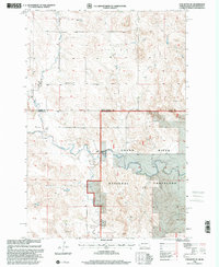
1998 Map of Cow Butte NE
USGS Topo · Published 2001About this map
North Fork Grand River winds across this landscape, marking a central drainage point for the high plains at the intersection of Adams and Perkins Counties. The topography is defined by the Seventh Standard Parallel North, which serves as the boundary between North Dakota and South Dakota. This late-twentieth-century survey documents a sparsely populated ranching region, anchored by the Grand River National Grassland. Cultural landmarks like the North Grand Ch and its adjacent Cem reflect the spiritual and community centers of the local homesteading legacy. Numerous named watercourses, including Lightning Creek and Horse Creek, carve through the Holden terrain, while the K Johnson Ranch provides a specific point of reference for family history researchers tracing land use and settlement patterns in this borderland area.
Find a feature on this map
14 named features on this map. Tap any name to fly to it.
Don’t see what you’re looking for? This feature index may not catch every label — zoom into the map to look around manually.
Map Details
Editions of this 1998 Cow Butte NE Map
This is the sole edition of this map. No revisions or reprints were ever made.
Other maps of this area

1953 · Dickinson
USGS Topo · 1:250,000

1954 · Lemmon
USGS Topo · 1:250,000

1957 · Dickinson
USGS Topo · 1:250,000

1957 · Lemmon
USGS Topo · 1:250,000

1969 · Reeder
USGS Topo · 1:24,000

1974 · Hettinger North
USGS Topo · 1:24,000

1974 · Hettinger South
USGS Topo · 1:24,000

1974 · Cow Butte
USGS Topo · 1:24,000

1974 · Cow Butte NE
USGS Topo · 1:24,000

1980 · Mott
USGS Topo · 1:100,000