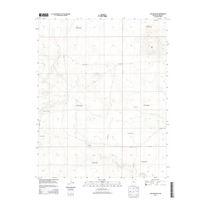
2013 Map of Cow Mountain
USGS Topo · Published 2013About this map
Cow Mtn rises above the high plains of northeastern New Mexico, anchoring a landscape defined by its sparse water sources and essential ranching infrastructure. The drainage systems of Gallegos Cr and Carrizo Cr cut through the terrain, providing the natural topography for land management in Union County. The importance of groundwater in this arid environment is evidenced by the wide distribution of named landmarks such as Sintas Windmill, Bryson Windmill, and Marsellino Windmill. These features, alongside local routes like CO Highway A-012 and CO Road AD10, illustrate a modern rural economy still deeply tied to the historical patterns of western livestock grazing. The map meticulously documents the intersection of Public Land Survey System boundaries, including t27n r29e and t27n r30e, which continue to dictate the layout of this open ranch land.
Find a feature on this map
22 named features on this map. Tap any name to fly to it.
Don’t see what you’re looking for? This feature index may not catch every label — zoom into the map to look around manually.
Map Details
Editions of this 2013 Cow Mountain Map
This is the sole edition of this map. No revisions or reprints were ever made.
Other maps of this area

1954 · Dalhart
USGS Topo · 1:250,000

1958 · Dalhart
USGS Topo · 1:250,000

1962 · Dalhart
USGS Topo · 1:250,000

1972 · Little Grande
USGS Topo · 1:24,000

1972 · Capulin
USGS Topo · 1:24,000

1972 · Malpie Mountain
USGS Topo · 1:24,000

1972 · Cow Mountain
USGS Topo · 1:24,000
1973 · Wetherly Lake
USGS Topo · 1:24,000

1973 · Gladstone NW
USGS Topo · 1:24,000

1973 · Grenville SW
USGS Topo · 1:24,000