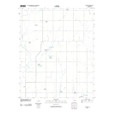
2009 Map of Cowden
USGS Topo · Published 2009About this map
The Washita River winds through this section of Washita County, carving a path through an agricultural landscape defined by a sophisticated water management network. A series of flood control structures and reservoirs, such as Oknoname 149015 Reservoir and the Cowden Laterals Site 4 Reservoir, are interspersed among several creek systems. The terrain is drained by Spring Creek, Gyp Creek, and Cottonwood Creek, all feeding into the larger river basin. Evidence of the local community's heritage is anchored by the Oakdale Cemetery in the southwestern quadrant, while a grid of rural routes like Payne Lake Rd facilitates movement across the plains. This landscape reflects the intersection of natural hydrology and engineering, where dams like the Cavalry Creek Site 1 Dam protect the surrounding farmland from the erratic Oklahoma water cycles.
Find a feature on this map
38 named features on this map. Tap any name to fly to it.
Don’t see what you’re looking for? This feature index may not catch every label — zoom into the map to look around manually.
Map Details
Editions of this 2009 Cowden Map
This is the sole edition of this map. No revisions or reprints were ever made.
Other maps of this area

1955 · Clinton
USGS Topo · 1:250,000

1956 · Cordell
USGS Topo · 1:62,500

1957 · Clinton
USGS Topo · 1:250,000

1961 · Gotebo
USGS Topo · 1:62,500

1961 · Eakly
USGS Topo · 1:62,500

1961 · Carnegie
USGS Topo · 1:62,500

1983 · Cloud Chief
USGS Topo · 1:24,000

1984 · Gotebo East
USGS Topo · 1:24,000

1984 · Eakly
USGS Topo · 1:24,000
1984 · Colony
USGS Topo · 1:24,000