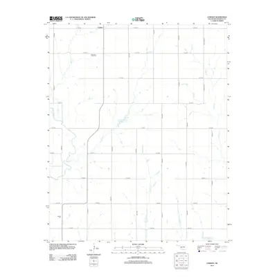
2012 Map of Cowden
USGS Topo · Published 2012About this map
Cowden is a localized focal point within this Oklahoma landscape, situated at the junction of section roads in a region defined by agricultural plots and managed water systems. The western edge of the area is carved by the meandering Washita River, while the interior drainage is facilitated by numerous seasonal streams including Spring Cr, Gyp Cr, and Cottonwood Cr. The land is dotted with vital local history markers, specifically the Sappington Chapel Cem and Oakdale Cem, which serve as primary genealogical anchors for the surrounding rural community. Man-made infrastructure is visible through the Cowden Laterals Site 4 Reservoir and Cowden Laterals Site 7 Reservoir, reflecting modern water management and soil conservation efforts that have shaped the plains of Washita County.
Find a feature on this map
27 named features on this map. Tap any name to fly to it.
Don’t see what you’re looking for? This feature index may not catch every label — zoom into the map to look around manually.
Map Details
Editions of this 2012 Cowden Map
This is the sole edition of this map. No revisions or reprints were ever made.
Other maps of this area

1955 · Clinton
USGS Topo · 1:250,000

1956 · Cordell
USGS Topo · 1:62,500

1957 · Clinton
USGS Topo · 1:250,000

1961 · Gotebo
USGS Topo · 1:62,500

1961 · Eakly
USGS Topo · 1:62,500

1961 · Carnegie
USGS Topo · 1:62,500

1983 · Cloud Chief
USGS Topo · 1:24,000

1984 · Gotebo East
USGS Topo · 1:24,000

1984 · Eakly
USGS Topo · 1:24,000
1984 · Colony
USGS Topo · 1:24,000