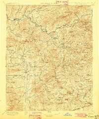
1897 Map of Cowee
USGS Topo · Published 1902About this map
The Tuckasegee River and the Tennessee River carve through these high mountain valleys in an era when river routes and early rail lines dictated the growth of western North Carolina. Along the Southern RR, settlements like Dillsboro and Sylva serve as vital hubs for the surrounding peaks. The map records the engineered landscape of the day, specifically the Cowee Tunnel and the winding rail path toward Balsam Gap. Local industrial and community life is anchored at Wests Mill and the town of Franklin, while the northern portion of the sheet illustrates the terrain of the Qualla Boundary, including Cherokee and Quallatown. High elevations like Plott Balsam and Cowee Bald define the physical limits of the mountain communities, showing a region where isolated gaps and river crossings were the primary links between settlements.
Find a feature on this map
170 named features on this map. Tap any name to fly to it.
Don’t see what you’re looking for? This feature index may not catch every label — zoom into the map to look around manually.
Map Details
Editions of this 1897 Cowee Map
4 editions found

Other maps of this area

1886 · Knoxville
USGS Topo · 1:125,000

1886 · Dahlonega
USGS Topo · 1:125,000

1886 · Walhalla
USGS Topo · 1:125,000

1888 · Pickens
USGS Topo · 1:125,000

1891 · Cowee
USGS Topo · 1:125,000

1892 · Dahlonega
USGS Topo · 1:125,000

1892 · Walhalla
USGS Topo · 1:125,000

1892 · Knoxville
USGS Topo · 1:125,000

1893 · Mt Guyot
USGS Topo · 1:125,000

1894 · Asheville
USGS Topo · 1:125,000