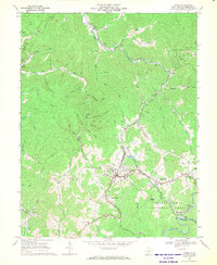
1966 Map of Cowen
USGS Topo · Published 1970About this map
The Baltimore and Ohio railroad corridor serves as the backbone of this mid-1960s landscape, threading through the narrow valleys of the Birch River and Laurel Creek. The settlement of Cowen emerges as a central hub, supported by a network of nearby mountain hamlets like Welch Glade, Arcola, and Wainville. This era reveals a transition in the local economy, where traditional upland farming and forestry in the Monongahela National Forest coexist with industrial activity, evidenced by numerous Strip Mines and Gas Wells appearing across the ridges. Genealogists will find particular value in the documentation of family-named landmarks and local burial sites, such as the Handschumacher Cem and Glade Summit Ch, providing a clear record of community distribution before later development altered these rural Webster County enclaves.
Find a feature on this map
64 named features on this map. Tap any name to fly to it.
Don’t see what you’re looking for? This feature index may not catch every label — zoom into the map to look around manually.
Map Details
Editions of this 1966 Cowen Map
2 editions found
Other maps of this area

1889 · Nicholas
USGS Topo · 1:125,000

1891 · Nicholas
USGS Topo · 1:125,000

1891 · Huntersville
USGS Topo · 1:125,000

1893 · Buckhannon
USGS Topo · 1:125,000

1893 · Sutton
USGS Topo · 1:125,000

1894 · Huntersville
USGS Topo · 1:125,000

1896 · Buckhannon
USGS Topo · 1:125,000

1897 · Buckhannon
USGS Topo · 1:125,000

1901 · Nicholas
USGS Topo · 1:125,000

1908 · Sutton
USGS Topo · 1:48,000