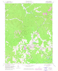
1966 Map of Cowen
USGS Topo · Published 1982About this map
Cowen serves as the central hub of this mid-1960s survey, where the Baltimore and Ohio tracks weave through a landscape shaped by coal and timber. The industrial character of the era is evident in the Strip Mine operations scattered across the hills and the Gas Well sites near the settlement. Despite this heavy industry, the map preserves the details of a community connected by faith and education, marking the Little Glade Sch, Halo Ch, and Glade View Ch.
Find a feature on this map
74 named features on this map. Tap any name to fly to it.
Don’t see what you’re looking for? This feature index may not catch every label — zoom into the map to look around manually.
Map Details
Editions of this 1966 Cowen Map
2 editions found
Other maps of this area

1889 · Nicholas
USGS Topo · 1:125,000

1891 · Nicholas
USGS Topo · 1:125,000

1891 · Huntersville
USGS Topo · 1:125,000

1893 · Buckhannon
USGS Topo · 1:125,000

1893 · Sutton
USGS Topo · 1:125,000

1894 · Huntersville
USGS Topo · 1:125,000

1896 · Buckhannon
USGS Topo · 1:125,000

1897 · Buckhannon
USGS Topo · 1:125,000

1901 · Nicholas
USGS Topo · 1:125,000

1908 · Sutton
USGS Topo · 1:48,000