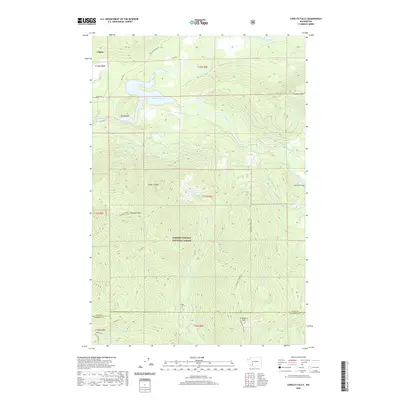
2020 Map of Cowlitz Falls
USGS Topo · Published 2020About this map
Lake Scanewa and the Cowlitz Falls power project dominate this mountainous portion of the Gifford Pinchot National Forest. The landscape is defined by the confluence of the Cowlitz River and the Cispus River, where the valley widens at Big Bottom before climbing into the high ridges of the Cascades. Named summits like Strawberry Mtn and Tumwater Peak surround the river basins, highlighting the extreme relief of the region. The map captures the infrastructure of the late twentieth-century hydroelectric development, showing the reservoir behind the falls alongside older landmarks like the Huffaker Bridge. Farther south, the terrain rises toward Goat Mountain and the headwaters of Quartz Cr, providing a detailed view of the forest service road networks and natural drainage patterns that have shaped this timber and recreation country for generations.
Find a feature on this map
35 named features on this map. Tap any name to fly to it.
Don’t see what you’re looking for? This feature index may not catch every label — zoom into the map to look around manually.
Map Details
Editions of this 2020 Cowlitz Falls Map
This is the sole edition of this map. No revisions or reprints were ever made.
Other maps of this area

1919 · Mount St Helens
USGS Topo · 1:125,000

1924 · Mt Rainier
USGS Topo · 1:96,000

1926 · Steamboat Mtn
USGS Topo · 1:125,000

1928 · Mt Rainier
USGS Topo · 1:125,000

1931 · Steamboat Mtn
USGS Topo · 1:125,000

1937 · Eatonville
USGS Topo · 1:125,000

1950 · Yakima
USGS Topo · 1:250,000

1953 · Hoquiam
USGS Topo · 1:250,000

1956 · Mineral
USGS Topo · 1:62,500

1957 · Hoquiam
USGS Topo · 1:250,000