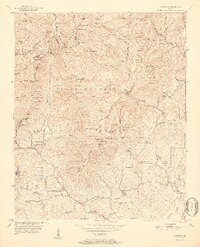
1952 Map of Cowrock
USGS Topo · Published 1952About this map
Appalachian Trail hikers and local genealogists find a wealth of details in this mid-century survey of the White and Lumpkin county border. The high ridgelines of the Chattahoochee National Forest are punctuated by numerous gaps and tops, including Tesnatee Gap and Hogpen Gap along the Blue Ridge Divide. The southern half of the map reveals a focused network of rural community centers, primarily anchored by churches and schools. Local landmarks like Mt Pleasant Ch & Cem, Loudsville Ch, and the Blue Ridge Sch indicate the settlement pattern of the valley floors beneath the steep slopes of the Hickorynut Lead. Numerous branches and creeks, such as Dukes Creek and Town Creek, drain the high country, where the landscape is defined by traditional place names like Turkeypen Flats and Wolfpen Stamp.
Find a feature on this map
120 named features on this map. Tap any name to fly to it.
Don’t see what you’re looking for? This feature index may not catch every label — zoom into the map to look around manually.
Map Details
Editions of this 1952 Cowrock Map
2 editions found
Other maps of this area

1886 · Dahlonega
USGS Topo · 1:125,000

1892 · Dahlonega
USGS Topo · 1:125,000

1896 · Dahlonega
USGS Topo · 1:125,000

1903 · Dahlonega
USGS Topo · 1:125,000

1935 · Coosa Bald
USGS Topo · 1:24,000

1935 · Cowrock
USGS Topo · 1:24,000

1935 · Tray Mountain
USGS Topo · 1:24,000

1935 · Jacks Gap
USGS Topo · 1:24,000
1935 · Neels Gap
USGS Topo · 1:24,000

1938 · Cowrock
USGS Topo · 1:24,000