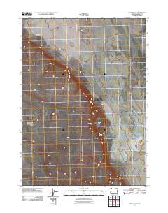
2011 Map of Coyote Gap
USGS Topo · Published 2011About this map
Old Military Rd cuts across the northern edge of this high desert landscape in Harney County, following a historic transit corridor through the southeastern Oregon plateau. The topography is dominated by the namesake Coyote Gap, a natural passage between higher elevations that has long served as a focal point for movement in this arid region. Near the center of the sheet, the Coyote Gap Corral indicates the enduring ranching and livestock heritage of the area. Modern access is primarily provided by Catlow Valley Rd, which intersects the older survey routes. The map illustrates a vast, sparsely settled drainage network where seasonal watercourses gather, highlighting the essential relationship between geography and survival in the remote basins of the Oregon interior.
Find a feature on this map
4 named features on this map. Tap any name to fly to it.
Don’t see what you’re looking for? This feature index may not catch every label — zoom into the map to look around manually.
Map Details
Editions of this 2011 Coyote Gap Map
This is the sole edition of this map. No revisions or reprints were ever made.
Other maps of this area

1955 · Adel
USGS Topo · 1:250,000

1957 · Adel
USGS Topo · 1:250,000

1958 · Adel
USGS Topo · 1:250,000

1962 · Adel
USGS Topo · 1:250,000

1971 · Fish Fin Rim
USGS Topo · 1:24,000

1971 · Square Mountain
USGS Topo · 1:24,000

1971 · Surveyors Lake
USGS Topo · 1:24,000

1971 · Blitzen
USGS Topo · 1:24,000

1971 · Coyote Gap SE
USGS Topo · 1:24,000

1971 · Garrison Lake
USGS Topo · 1:24,000