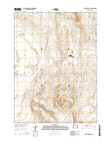
2014 Map of Coyote Lake East
USGS Topo · Published 2014About this map
Coyote Lake dominates the western portion of this high-desert landscape in Malheur County, appearing as a broad, stippled playa. The basin is bounded to the east by the rising elevations of the Crooked Creek Range, where the topography becomes increasingly complex with deep drainage patterns and ridges. This 2014 survey documents the remote southeastern corner of Oregon, showing the Public Land Survey System grid across townships t34s r37e, t34s r38e, t35s r37e, and t35s r38e. The map illustrates a stark, arid environment where water is the primary geographic driver, centered on the expanse of Coyote Lk.
Find a feature on this map
7 named features on this map. Tap any name to fly to it.
Don’t see what you’re looking for? This feature index may not catch every label — zoom into the map to look around manually.
Map Details
Editions of this 2014 Coyote Lake East Map
This is the sole edition of this map. No revisions or reprints were ever made.
Other maps of this area

1955 · Jordan Valley
USGS Topo · 1:250,000

1955 · Adel
USGS Topo · 1:250,000

1957 · Adel
USGS Topo · 1:250,000

1957 · Jordan Valley
USGS Topo · 1:250,000

1958 · Adel
USGS Topo · 1:250,000

1958 · Jordan Valley
USGS Topo · 1:250,000

1962 · Adel
USGS Topo · 1:250,000
1980 · Flat Top Mtn
USGS Topo · 1:24,000

1980 · Rome State Airport
USGS Topo · 1:24,000

1981 · Coyote Lake West
USGS Topo · 1:24,000