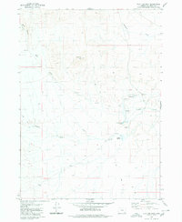
1980 Map of Flat Top Mtn
USGS Topo · Published 1980About this map
Flat Top Mtn serves as the central landmark for this high-desert region of southeastern Oregon during the late 1970s. The landscape is defined by a sparse but essential network of water sources and seasonal drainages, where life and transit revolve around remote points like Crooked Creek Spring and Pothole Springs. The presence of a Landing Strip and a Corral in the eastern portion of the quadrangle suggests the area's continued use for large-scale ranching operations and backcountry access. Significant erosion is evident in the northern reaches where Bone Canyon feeds into the winding path of Bone Creek. While largely unpopulated, a series of unnamed Jeep Trails provides the primary means of navigating between these scattered landmarks and water bodies like Drought Creek and Wildcat Creek, reflecting the traditional land use patterns of Malheur County.
Find a feature on this map
15 named features on this map. Tap any name to fly to it.
Don’t see what you’re looking for? This feature index may not catch every label — zoom into the map to look around manually.
Map Details
Editions of this 1980 Flat Top Mtn Map
This is the sole edition of this map. No revisions or reprints were ever made.
Other maps of this area

1955 · Jordan Valley
USGS Topo · 1:250,000

1955 · Adel
USGS Topo · 1:250,000

1957 · Adel
USGS Topo · 1:250,000

1957 · Jordan Valley
USGS Topo · 1:250,000

1958 · Adel
USGS Topo · 1:250,000

1958 · Jordan Valley
USGS Topo · 1:250,000

1962 · Adel
USGS Topo · 1:250,000

1972 · Palomino Hills
USGS Topo · 1:24,000
1972 · Burns Junction
USGS Topo · 1:24,000

1979 · Anderson Reservoir
USGS Topo · 1:24,000