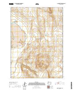
2020 Map of Coyote Lake East
USGS Topo · Published 2020About this map
Crooked Creek Range dominates the topography of this high desert terrain in Malheur County, providing a detailed view of the ridges and drainage patterns defining the eastern edge of the Coyote Lake basin. The primary artery through this isolated landscape is the Crooked Creek Range Rd, which snakes through the eastern sections of the quadrangle. This 2020 survey documents the modern land management divisions, specifically t34s r37e, t34s r38e, t35s r37e, and t35s r38e. The lack of named settlements or permanent structures emphasizes the region's character as a working rangeland and open natural space, where the 10-foot contour intervals reveal the intricate folding of the land between the road and the higher summits.
Find a feature on this map
6 named features on this map. Tap any name to fly to it.
Don’t see what you’re looking for? This feature index may not catch every label — zoom into the map to look around manually.
Map Details
Editions of this 2020 Coyote Lake East Map
This is the sole edition of this map. No revisions or reprints were ever made.
Other maps of this area

1955 · Jordan Valley
USGS Topo · 1:250,000

1955 · Adel
USGS Topo · 1:250,000

1957 · Adel
USGS Topo · 1:250,000

1957 · Jordan Valley
USGS Topo · 1:250,000

1958 · Adel
USGS Topo · 1:250,000

1958 · Jordan Valley
USGS Topo · 1:250,000

1962 · Adel
USGS Topo · 1:250,000
1980 · Flat Top Mtn
USGS Topo · 1:24,000

1980 · Rome State Airport
USGS Topo · 1:24,000

1981 · Coyote Lake West
USGS Topo · 1:24,000