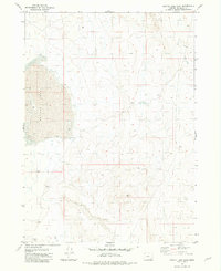
1981 Map of Coyote Lake East
USGS Topo · Published 1981About this map
Coyote Lake dominates the western portion of this 1981 survey, where its expansive, dry alkali bed meets the southeastern high desert of Malheur County. This area is characterized by vast drainage patterns and seasonal water features, including the presence of Duck Cr in the southern sections. The landscape is a study in basin-and-range topography, where the flat expanse of the lake bed transitions into rising elevations and complex contour intervals. Because this region was mapped via photogrammetric methods from 1974 aerial photography and field-checked in 1976, it provides a precise record of the desert terrain before any modern alterations. Geologists and environmental researchers can trace the ancient shoreline of the lake and the intermittent flow paths that define this isolated stretch of the Oregon desert.
Find a feature on this map
2 named features on this map. Tap any name to fly to it.
Don’t see what you’re looking for? This feature index may not catch every label — zoom into the map to look around manually.
Map Details
Editions of this 1981 Coyote Lake East Map
This is the sole edition of this map. No revisions or reprints were ever made.
Other maps of this area

1955 · Jordan Valley
USGS Topo · 1:250,000

1955 · Adel
USGS Topo · 1:250,000

1957 · Adel
USGS Topo · 1:250,000

1957 · Jordan Valley
USGS Topo · 1:250,000

1958 · Adel
USGS Topo · 1:250,000

1958 · Jordan Valley
USGS Topo · 1:250,000

1962 · Adel
USGS Topo · 1:250,000
1980 · Flat Top Mtn
USGS Topo · 1:24,000

1980 · Rome State Airport
USGS Topo · 1:24,000

1981 · Coyote Lake West
USGS Topo · 1:24,000