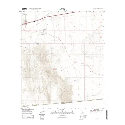
2015 Map of Coyote Wells
USGS Topo · Published 2015About this map
Coyote Wells and the neighboring settlement of Ocotillo occupy the high desert floor at the northern edge of this 2015 survey, where the Evan Hewes Hwy serves as a primary transit corridor. The map details the transition from these residential pockets into the arid expanses of the Yuha Desert and the Yuha Basin to the east. Of particular interest to historical researchers is the Anza Trl, which winds through the central and eastern portions of the quadrangle, tracing a path through the low-lying drainage of the S Fork Coyote Wash. To the south and west, the terrain rises sharply into the complex topography of Davies Canyon and Pinto Canyon, eventually descending into the remote Davies Valley. The map concludes at the international border between the United States and Mexico, marked along the southern boundary of Imperial County.
Find a feature on this map
35 named features on this map. Tap any name to fly to it.
Don’t see what you’re looking for? This feature index may not catch every label — zoom into the map to look around manually.
Map Details
Editions of this 2015 Coyote Wells Map
This is the sole edition of this map. No revisions or reprints were ever made.
Other maps of this area

1915 · El Centro
USGS Topo · 1:125,000

1931 · Carrizo
USGS Topo · 1:125,000

1939 · Jacumba
USGS Topo · 1:62,500

1940 · Plaster City
USGS Topo · 1:62,500

1940 · Coyote Wells
USGS Topo · 1:62,500

1942 · El Centro
USGS Topo · 1:250,000

1942 · Carrizo Mtn
USGS Topo · 1:62,500

1942 · Jacumba
USGS Topo · 1:62,500

1943 · Coyote Wells
USGS Topo · 1:62,500

1944 · Plaster City
USGS Topo · 1:62,500