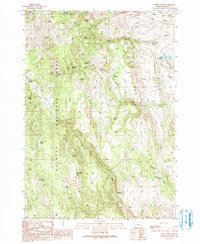
1990 Map of Craft Point
USGS Topo · Published 1991About this map
Malheur National Forest dominates this section of the Oregon high country, where the landscape is defined by the critical management of water in an arid environment. Numerous named springs, including Widow B Spring, Ralphs Spring, and Dietrich Spring, support the cattle operations that define the local economy. The presence of Miller Reservoir, Temple Reservoir, and Poer Reservoir illustrates the infrastructure built to sustain livestock across the diverse terrain of Oard Flat and the surrounding drainages. This high-elevation area is marked by prominent peaks and ridges such as Thompson Mountain, Mount Tom, and Elephant Butte. The map details the network of 4wd tracks and trails used by foresters and ranchers, leading to seasonal outposts like the Pine Creek Cow Camp. Geologic and industrial activity is noted at a Quarry near the base of Craft Point, reflecting the utility of the land beyond traditional grazing.
Find a feature on this map
46 named features on this map. Tap any name to fly to it.
Don’t see what you’re looking for? This feature index may not catch every label — zoom into the map to look around manually.
Map Details
Editions of this 1990 Craft Point Map
This is the sole edition of this map. No revisions or reprints were ever made.
Other maps of this area

1955 · Burns
USGS Topo · 1:250,000

1958 · Burns
USGS Topo · 1:250,000

1959 · Burns
USGS Topo · 1:250,000

1959 · Harney
USGS Topo · 1:62,500

1961 · Calamity Butte
USGS Topo · 1:62,500

1968 · Van
USGS Topo · 1:62,500

1973 · Buchanan
USGS Topo · 1:24,000
1978 · Stinkingwater Pass
USGS Topo · 1:24,000

1978 · Stinkingwater Mountains
USGS Topo · 1:100,000
1990 · Calamity Butte
USGS Topo · 1:24,000