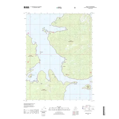
2017 Map of Craig B-4 SW
USGS Topo · Published 2017About this map
Waterfall stands as the primary shorebound settlement along the eastern coast of the Ulloa Channel in this coastal Alaskan study. Located within the Tongass National Forest, the map depicts a complex marine environment where the Suezmez Island landmass is separated from the mainland by narrow passages. The maritime infrastructure of the early 21st century is evident in the charted approaches to Port Refugio and Port Estrella, where landforms like Cape Flores and Point Providence define the navigable waters. This geography illustrates a landscape defined by water-access, with limited terrestrial transport routes like the Suemez Highway and W Port Refugio providing the only developed inland connections across the larger islands. Smaller landmarks such as Isla Buen Ayre and Verde Island provide essential navigation points within the intricate network of bays and inlets.
Find a feature on this map
30 named features on this map. Tap any name to fly to it.
Don’t see what you’re looking for? This feature index may not catch every label — zoom into the map to look around manually.
Map Details
Editions of this 2017 Craig B-4 SW Map
This is the sole edition of this map. No revisions or reprints were ever made.
Other maps of this area

1948 · Craig A-4
USGS Topo · 1:63,360

1948 · Craig B-5
USGS Topo · 1:63,360

1948 · Craig A-5
USGS Topo · 1:63,360

1949 · Craig B-4
USGS Topo · 1:63,360

1951 · Craig B-4
USGS Topo · 1:63,360

1951 · Craig A-4
USGS Topo · 1:63,360

1957 · Craig
USGS Topo · 1:250,000
1994 · Craig A-4
USGS Topo · 1:63,360

2000 · Craig B-5
USGS Topo · 1:63,360
2017 · Craig B-4 NE
USGS Topo · 1:25,000