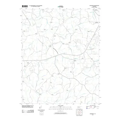
2010 Map of Craigfield
USGS Topo · Published 2010About this map
Fairview and its surrounding countryside are defined by a complex network of burial sites and winding waterways that traverse the Williamson County line. This rural landscape is heavily mapped with family and community graveyards, including the Craigfield Cemetery, Mangrum Cemetery, and Lampley Cemetery, suggesting a deep-rooted genealogical history across the hills. The terrain is deeply incised by the Big Turnbull Creek and South Harpeth Creek systems, with Lake Weona providing a central water feature secured by the Lake Weona Dam. The settlement pattern here follows the narrow valleys and ridges, with numerous branches like Tidwell Branch and Bice Creek dictating the placement of historic farmsteads and the winding paths of roads like Old Pinewood Rd.
Find a feature on this map
124 named features on this map. Tap any name to fly to it.
Don’t see what you’re looking for? This feature index may not catch every label — zoom into the map to look around manually.
Map Details
Editions of this 2010 Craigfield Map
This is the sole edition of this map. No revisions or reprints were ever made.
Other maps of this area

1901 · Colombia
USGS Topo · 1:125,000

1930 · White Bluff
USGS Topo · 1:62,500

1933 · White Bluff
USGS Topo · 1:62,500

1936 · Primm
USGS Topo · 1:24,000

1936 · Littlelot
USGS Topo · 1:24,000

1936 · Theta
USGS Topo · 1:24,000

1936 · Burns
USGS Topo · 1:24,000

1936 · Craigfield
USGS Topo · 1:24,000

1936 · Lyles
USGS Topo · 1:24,000
1951 · Theta
USGS Topo · 1:24,000