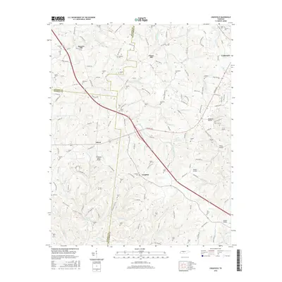
2016 Map of Craigfield
USGS Topo · Published 2016About this map
The Tennessee Valley Divide snakes through this landscape on the border of Dickson, Hickman, and Williamson counties, separating the waters flowing toward the Cumberland and Tennessee rivers. This topographic study captures a transition between the established community of Fairview and the rural crossroads of Tidwell and Craigfield. The map is particularly dense with family cemeteries, including the Lampley Cem, Richardson Cem, and Fowlkes Cem, offering a detailed look at the ancestral burial grounds of these middle Tennessee ridges. A network of country roads like Old Nashville Rd and Old Hillsboro Rd follows the high ground, while numerous watercourses such as Big Turnbull Cr and Younger Cr carve the hollows. Large tracts like Mangrum Hollow and Sleepy Hollow define the drainage patterns that have shaped local agriculture and settlement since the nineteenth century.
Find a feature on this map
146 named features on this map. Tap any name to fly to it.
Don’t see what you’re looking for? This feature index may not catch every label — zoom into the map to look around manually.
Map Details
Editions of this 2016 Craigfield Map
This is the sole edition of this map. No revisions or reprints were ever made.
Other maps of this area

1901 · Colombia
USGS Topo · 1:125,000

1930 · White Bluff
USGS Topo · 1:62,500

1933 · White Bluff
USGS Topo · 1:62,500

1936 · Primm
USGS Topo · 1:24,000

1936 · Littlelot
USGS Topo · 1:24,000

1936 · Theta
USGS Topo · 1:24,000

1936 · Burns
USGS Topo · 1:24,000

1936 · Craigfield
USGS Topo · 1:24,000

1936 · Lyles
USGS Topo · 1:24,000
1951 · Theta
USGS Topo · 1:24,000