
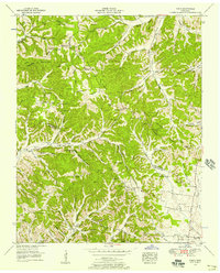
1936 Map of Craigfield
USGS Topo · Published 1936About this map
The Hickman and Williamson county line bisects this mid-1930s landscape, where rural life is anchored by a network of small schoolhouses and country churches. The small settlement of Craigfield sits near the center of the sheet, surrounded by family-named landmarks like McCord Cem and Beard Cem. The terrain is defined by the Basin Divide, with water flowing through the Locust Fork and Younger Creek valleys. Modern infrastructure is represented by the Tennessee Electric Power Company Transmission Line and Tennessee State Highway No 100, which cut across the northern portion of the quadrangle. For those researching local genealogy, the distribution of schools such as Allen Sch and Postoak Sch, alongside congregations at Greens Chapel and Oak Grove Ch, provides a clear view of community hubs before mid-century shifts.
Find a feature on this map
34 named features on this map. Tap any name to fly to it.
Don’t see what you’re looking for? This feature index may not catch every label — zoom into the map to look around manually.
Map Details
Editions of this 1936 Craigfield Map
This is the sole edition of this map. No revisions or reprints were ever made.
Other maps of this area

1901 · Colombia
USGS Topo · 1:125,000

1930 · White Bluff
USGS Topo · 1:62,500

1933 · White Bluff
USGS Topo · 1:62,500

1936 · Primm
USGS Topo · 1:24,000

1936 · Littlelot
USGS Topo · 1:24,000

1936 · Theta
USGS Topo · 1:24,000

1936 · Burns
USGS Topo · 1:24,000

1936 · Lyles
USGS Topo · 1:24,000
1951 · Theta
USGS Topo · 1:24,000

1951 · Fairview
USGS Topo · 1:24,000