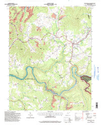
1995 Map of Craigsville
USGS Topo · Published 1998About this map
Summersville Lake dominates the central landscape of this Nicholas County region, where the Gauley River carves a deep, winding path through the plateau. This mid-1990s survey illustrates a rural economy transitioning from resource extraction to recreation and regional services. While Mine symbols and a large Conveyor system near Marybill point to the area's industrial heritage, the presence of the Summersville Lake Public Hunting and Fishing Area and the Monongahela National Forest boundary reflects the growing importance of the outdoors. The town of Craigsville serves as a local hub, featuring a Drive-in Theater and proximity to the Herold Airport. Further south, the Richwood Municipal Airport sits near Lick Creek, while scattered hamlets like Calvin and Donald are marked by their small churches and schools, such as Little Union Ch and the Oak Grove Sch.
Find a feature on this map
75 named features on this map. Tap any name to fly to it.
Don’t see what you’re looking for? This feature index may not catch every label — zoom into the map to look around manually.
Map Details
Editions of this 1995 Craigsville Map
This is the sole edition of this map. No revisions or reprints were ever made.
Other maps of this area

1889 · Nicholas
USGS Topo · 1:125,000

1891 · Nicholas
USGS Topo · 1:125,000

1901 · Nicholas
USGS Topo · 1:125,000

1913 · Summersville
USGS Topo · 1:48,000

1914 · Winona
USGS Topo · 1:48,000

1915 · Cowen
USGS Topo · 1:48,000
1915 · Summersville
USGS Topo · 1:62,500

1916 · Winona
USGS Topo · 1:62,500

1917 · Cowen
USGS Topo · 1:62,500

1918 · Richwood
USGS Topo · 1:62,500