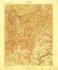
1915 Map of Summersville
USGS Topo · Published 1915About this map
Summersville and the surrounding Nicholas County highlands are defined by a complex network of ridges and river valleys in this 1913 survey. The landscape is dotted with early 20th-century rural infrastructure, including a high concentration of local schools such as Eberly School, Winebrenner School, and Peeks School, reflecting the scattered settlement patterns of the era. Significant terrain features like Powell Mountain and Browns Ridge dominate the topography, while movement across the water relied on traditional crossings like Persinger Ford and Brocks Bridge. The map also documents industrial and timber-related settlements like Swandale and Widen in their formative years, alongside smaller communities such as Hookersville and Gilboa.
Find a feature on this map
83 named features on this map. Tap any name to fly to it.
Don’t see what you’re looking for? This feature index may not catch every label — zoom into the map to look around manually.
Map Details
Editions of this 1915 Summersville Map
3 editions found
Other maps of this area

1889 · Nicholas
USGS Topo · 1:125,000

1891 · Nicholas
USGS Topo · 1:125,000

1893 · Sutton
USGS Topo · 1:125,000

1897 · Kanawha Falls
USGS Topo · 1:125,000

1900 · Kanawha Falls
USGS Topo · 1:125,000

1901 · Nicholas
USGS Topo · 1:125,000

1901 · Kanawha Falls
USGS Topo · 1:125,000

1906 · Otter
USGS Topo · 1:62,500

1907 · Otter
USGS Topo · 1:62,500

1908 · Clay
USGS Topo · 1:48,000