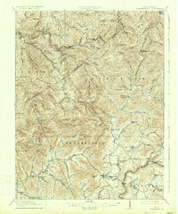
1915 Map of Summersville
USGS Topo · Published 1934About this map
Summersville serves as the focal point of this 1913 survey, situated south of the high ridgelines of Powell Mountain and Browns Ridge. The landscape is defined by the intricate drainage of Muddlety Creek and Peters Creek, with numerous small schools like the Winebrenner School and Eberly School dotting the hollows to serve rural family farms. Evidence of early infrastructure and memorialization appears at Persinger Ford and the Youngs Monument, indicating established travel routes and local legacies prior to modern highway development. To the north, industrial settlements like Swandale and Widen emphasize the era's reliance on the timber and coal resources of the Buffalo Creek drainage, while the southern reaches near Tiptop and Canvas show a transition toward more concentrated township life.
Find a feature on this map
98 named features on this map. Tap any name to fly to it.
Don’t see what you’re looking for? This feature index may not catch every label — zoom into the map to look around manually.
Map Details
Editions of this 1915 Summersville Map
3 editions found
Other maps of this area

1889 · Nicholas
USGS Topo · 1:125,000

1891 · Nicholas
USGS Topo · 1:125,000

1893 · Sutton
USGS Topo · 1:125,000

1897 · Kanawha Falls
USGS Topo · 1:125,000

1900 · Kanawha Falls
USGS Topo · 1:125,000

1901 · Nicholas
USGS Topo · 1:125,000

1901 · Kanawha Falls
USGS Topo · 1:125,000

1906 · Otter
USGS Topo · 1:62,500

1907 · Otter
USGS Topo · 1:62,500

1908 · Clay
USGS Topo · 1:48,000