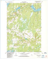
1984 Map of Cranberry Lake
USGS Topo · Published 1984About this map
The Elk River and Little Elk River define the watery landscape of Price County in this 1980s-era topographical study, revealing a region defined by its timber and lake resources. The map highlights the transition between the townships of Worcester, Emery, and Hackett, where industrial and natural features coincide. The presence of the Soo Line railroad and a crossing Pipeline underscores the area's role as a transit corridor for northern Wisconsin commodities.
Find a feature on this map
45 named features on this map. Tap any name to fly to it.
Don’t see what you’re looking for? This feature index may not catch every label — zoom into the map to look around manually.
Map Details
Editions of this 1984 Cranberry Lake Map
This is the sole edition of this map. No revisions or reprints were ever made.
Other maps of this area

1941 · Park Falls
USGS Topo · 1:48,000

1941 · Pike Lake
USGS Topo · 1:48,000

1941 · Phillips
USGS Topo · 1:48,000

1941 · Brantwood
USGS Topo · 1:48,000

1942 · Pike Lake
USGS Topo · 1:48,000

1943 · Park Falls
USGS Topo · 1:48,000

1943 · Philliips
USGS Topo · 1:48,000

1943 · Brantwood
USGS Topo · 1:48,000

1947 · Park Falls
USGS Topo · 1:48,000

1950 · Pike Lake
USGS Topo · 1:48,000