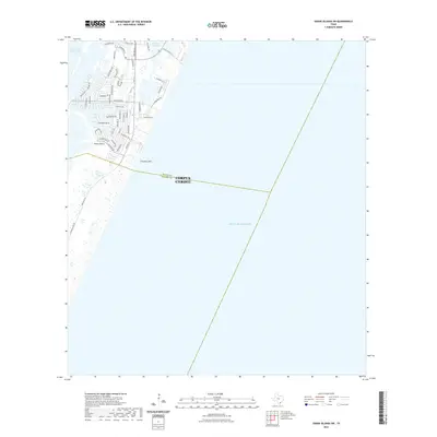
2022 Map of Crane Islands SW
USGS Topo · Published 2022About this map
Padre Island serves as the focal point of this coastal survey, where the suburban expansion of Corpus Christi meets the shifting sands of the Texas coast. The map illustrates a dense network of residential streets such as White Cap Blvd and Park Rd 22 that transition into the undeveloped shoreline of the Gulf of Mexico. The development pattern is deeply influenced by the surrounding water, with finger canals and lagoons providing water access to numerous properties. To the north, the Intracoastal Waterway and Packery Channel highlight the area's importance for both navigation and recreation. A distinct municipal boundary divides the landscape where the Nueces Co and Kleberg Co line cuts across the island near Fourmile Hill, marking a administrative shift in this seafaring community.
Find a feature on this map
48 named features on this map. Tap any name to fly to it.
Don’t see what you’re looking for? This feature index may not catch every label — zoom into the map to look around manually.
Map Details
Editions of this 2022 Crane Islands SW Map
This is the sole edition of this map. No revisions or reprints were ever made.
Other maps of this area

1925 · Oso Creek
USGS Topo · 1:62,500

1950 · Corpus Christi
USGS Topo · 1:250,000

1951 · South Bird Island
USGS Topo · 1:24,000

1951 · Crane Islands NW
USGS Topo · 1:24,000

1951 · Oso Creek NE
USGS Topo · 1:24,000

1951 · Crane Islands SW
USGS Topo · 1:24,000

1951 · Oso Creek
USGS Topo · 1:62,500

1951 · Crane Islands
USGS Topo · 1:62,500

1951 · South Bird Island
USGS Topo · 1:62,500

1956 · Corpus Christi
USGS Topo · 1:250,000