
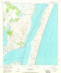
1951 Map of South Bird Island
USGS Topo · Published 1957About this map
Laguna Madre dominates this 1951 coastal survey, separating the mainland of Kleberg and Kenedy Counties from the shifting dunes of Padre Island. The landscape is defined by the vital necessity of water in this semi-arid environment, evidenced by a dense network of private ranch infrastructure including Becerra Wells, Ojo de Agua, and numerous artesian sources like Parra Artesian Well and Esperanza Artesian Well. Along the coast, the Intracoastal Waterway cuts through the shallow waters, providing a navigable corridor between South Bird Island and the mainland points of Alazan Mott and Point of Rocks. Significant military presence is noted at Naval Outlying Field 42 (Practice) near Oso Creek. The interior is crisscrossed with private roads connecting isolated sites like El Martillo and various windmills, reflecting the era's expansive cattle ranching operations before modern development transformed the shoreline.
Find a feature on this map
60 named features on this map. Tap any name to fly to it.
Don’t see what you’re looking for? This feature index may not catch every label — zoom into the map to look around manually.
Map Details
Editions of this 1951 South Bird Island Map
2 editions found
Other maps of this area

1924 · Petronilla
USGS Topo · 1:62,500

1925 · Oso Creek
USGS Topo · 1:62,500

1928 · Sarita
USGS Topo · 1:125,000

1950 · Corpus Christi
USGS Topo · 1:250,000

1951 · South Bird Island
USGS Topo · 1:24,000

1951 · South Bird Island SE
USGS Topo · 1:24,000

1951 · South Bird Island NW
USGS Topo · 1:24,000

1951 · Point Of Rocks
USGS Topo · 1:24,000

1951 · Kleberg Point
USGS Topo · 1:24,000

1951 · Crane Islands SW
USGS Topo · 1:24,000