
1951 Map of Point Of Rocks
USGS Topo · Published 1953About this map
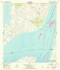
Baffin Bay and Alazan Bay dominate this coastal landscape at the beginning of the 1950s, marking the shallow, hypersaline waters where Kleberg and Kenedy counties meet. The map reveals a remote ranching and maritime environment where freshwater was secured through isolated sites like the El Tule Artesian Well and Calabo Artesian Well. Small settlements and outposts such as El Martillo and Compuerta are scattered across a terrain of sand and mud, while the newly established Intracoastal Waterway cuts through the Laguna Madre to the east. Landmarks like Point of Rocks and the prominent Penascal Rincon peninsula provide essential orientation points along this stretch of the Texas Gulf Coast, characterized by complex shoreline features and artificial spoil areas from dredging operations.
Find a feature on this map
19 named features on this map. Tap any name to fly to it.
Don’t see what you’re looking for? This feature index may not catch every label — zoom into the map to look around manually.
Map Details
Editions of this 1951 Point Of Rocks Map
2 editions found
Other maps of this area

1928 · Sarita
USGS Topo · 1:125,000

1950 · Corpus Christi
USGS Topo · 1:250,000

1951 · South Bird Island
USGS Topo · 1:24,000

1951 · South Bird Island SE
USGS Topo · 1:24,000

1951 · South Bird Island NW
USGS Topo · 1:24,000

1951 · Kleberg Point
USGS Topo · 1:24,000

1951 · Riviera Beach NE
USGS Topo · 1:24,000

1951 · Sarita 4 NE
USGS Topo · 1:24,000

1951 · South Bird Island
USGS Topo · 1:62,500

1952 · Yarborough Pass
USGS Topo · 1:24,000