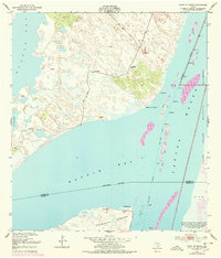
1951 Map of Point Of Rocks
USGS Topo · Published 1978About this map
Point of Rocks marks a distinctive protrusion into the coastal waters of South Texas, where the confluence of Alazan Bay, Baffin Bay, and the Laguna Madre creates a complex aquatic landscape. This 1951 survey, with later revisions, captures the remote ranching and maritime character of the Kleberg and Kenedy county line. Scattered outposts like El Martillo, Compuerta, and Kenedy are linked by private roads across terrain defined by sand, mud, and artesian sources such as El Tule Artesian Well and Calbero Artesian Well.
Find a feature on this map
24 named features on this map. Tap any name to fly to it.
Don’t see what you’re looking for? This feature index may not catch every label — zoom into the map to look around manually.
Map Details
Editions of this 1951 Point Of Rocks Map
2 editions found
Other maps of this area

1928 · Sarita
USGS Topo · 1:125,000

1950 · Corpus Christi
USGS Topo · 1:250,000

1951 · South Bird Island
USGS Topo · 1:24,000

1951 · South Bird Island SE
USGS Topo · 1:24,000

1951 · South Bird Island NW
USGS Topo · 1:24,000

1951 · Point Of Rocks
USGS Topo · 1:24,000

1951 · Kleberg Point
USGS Topo · 1:24,000

1951 · Riviera Beach NE
USGS Topo · 1:24,000

1951 · Sarita 4 NE
USGS Topo · 1:24,000

1951 · South Bird Island
USGS Topo · 1:62,500