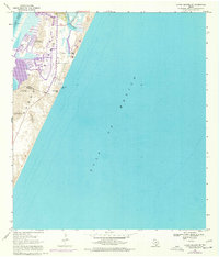
1968 Map of Crane Islands SW
USGS Topo · Published 1977About this map
Padre Island spans the length of this survey, dividing the turquoise waters of the Gulf of Mexico from the shallow reaches of Laguna Madre. The map captures the delicate topography of the barrier island during the late 1960s and mid-1970s, documented through shifting sand elevations that reach up to 34 feet. Human development is concentrated near the north, where Packery Channel cuts through to the Gulf and the Intracoastal Waterway facilitates maritime transit. Revisions from 1975 show expanding canal-front residential footprints near the County Park, contrasting with the more primitive southern stretches of the Padre Island National Seashore. Key navigational markers like Range A Light and leisure landmarks such as Bob Hall Pier reflect the island’s dual role as a critical coastal transit point and a growing recreational destination along the Nueces and Kleberg county line.
Find a feature on this map
16 named features on this map. Tap any name to fly to it.
Don’t see what you’re looking for? This feature index may not catch every label — zoom into the map to look around manually.
Map Details
Editions of this 1968 Crane Islands SW Map
This is the sole edition of this map. No revisions or reprints were ever made.
Other maps of this area

1925 · Oso Creek
USGS Topo · 1:62,500

1950 · Corpus Christi
USGS Topo · 1:250,000

1951 · South Bird Island
USGS Topo · 1:24,000

1951 · Crane Islands NW
USGS Topo · 1:24,000

1951 · Oso Creek NE
USGS Topo · 1:24,000

1951 · Crane Islands SW
USGS Topo · 1:24,000

1951 · Oso Creek
USGS Topo · 1:62,500

1951 · Crane Islands
USGS Topo · 1:62,500

1951 · South Bird Island
USGS Topo · 1:62,500

1956 · Corpus Christi
USGS Topo · 1:250,000