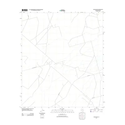
2012 Map of Crane SW
USGS Topo · Published 2012About this map
The arid Permian Basin landscape south of Crane, Texas, is defined by a sparse network of ranch and oilfield roads. The junction of Juan Cordona Lake Rd and Horsehead Rd serves as a primary navigation point in this wide expanse of Crane County. These thoroughfares, along with S Cowden Rd and Dawson Rd, trace the movement of industry and local ranching across the scrubland. Named for nearby geographic landmarks, Cordona Lake Rd leads toward the salt lake basins that characterize this part of West Texas. The absence of formal settlements highlights the specialized land use of the region during the early twenty-first century, where the map focus shifts to hydrology and the connectivity of remote access roads.
Find a feature on this map
5 named features on this map. Tap any name to fly to it.
Don’t see what you’re looking for? This feature index may not catch every label — zoom into the map to look around manually.
Map Details
Editions of this 2012 Crane SW Map
This is the sole edition of this map. No revisions or reprints were ever made.
Other maps of this area

1928 · Crane
USGS Topo · 1:125,000

1954 · Pecos
USGS Topo · 1:250,000

1957 · Pecos
USGS Topo · 1:250,000
1972 · Buena Vista NE
USGS Topo · 1:24,000

1972 · Girvin NE
USGS Topo · 1:24,000
1972 · Girvin NW
USGS Topo · 1:24,000

1974 · Tubbs Corner
USGS Topo · 1:24,000

1974 · Crane SW
USGS Topo · 1:24,000
1974 · Crane
USGS Topo · 1:24,000

1974 · Juan Cordona Lake
USGS Topo · 1:24,000